

San Juan Softie
100 mile Ultra Marathon
August 14, 2026
Durango, CO
SOLD OUT
Should You Run the Softie? from Brandon Mathis
The softest 100 miler in the San Juans
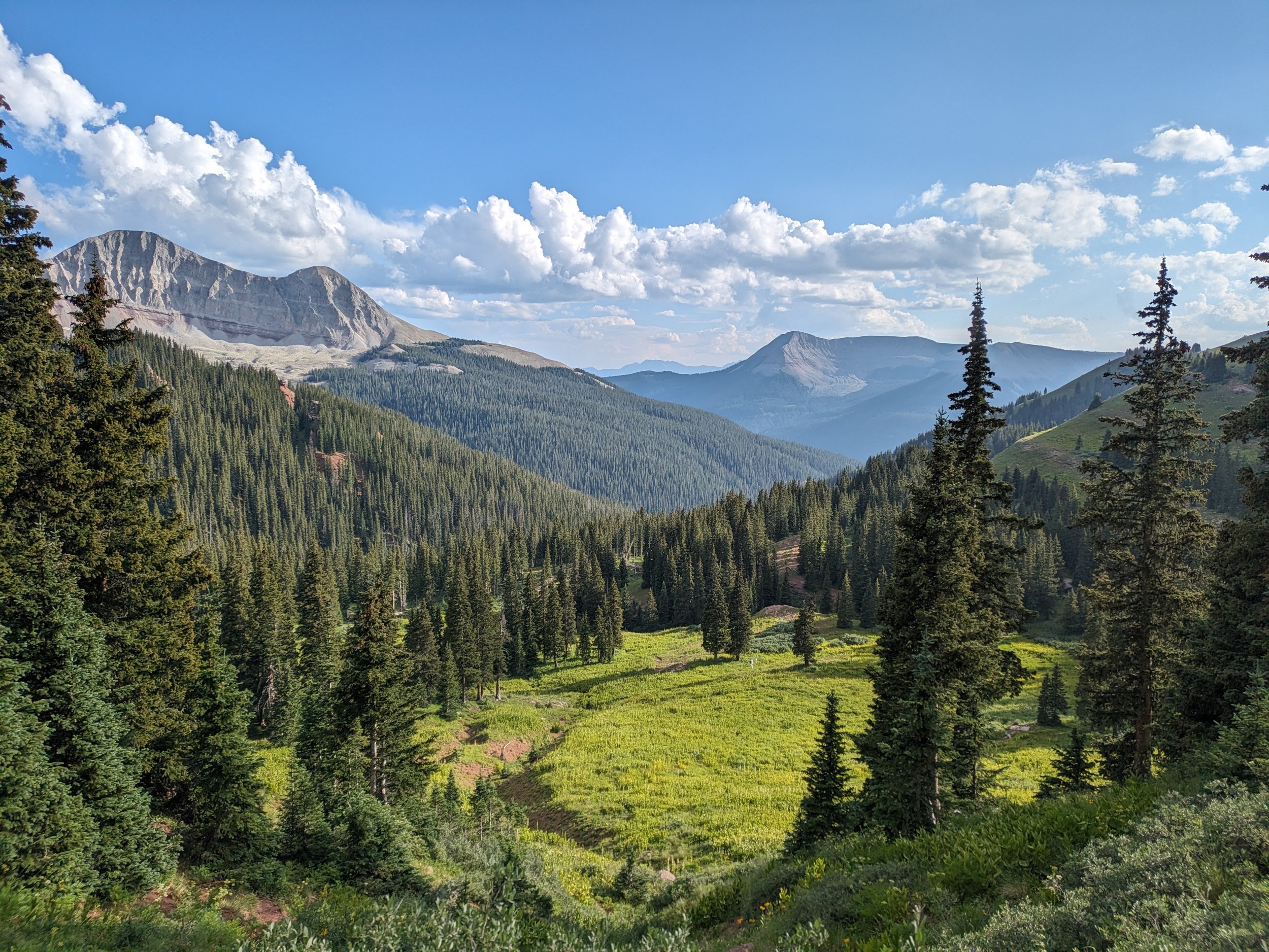
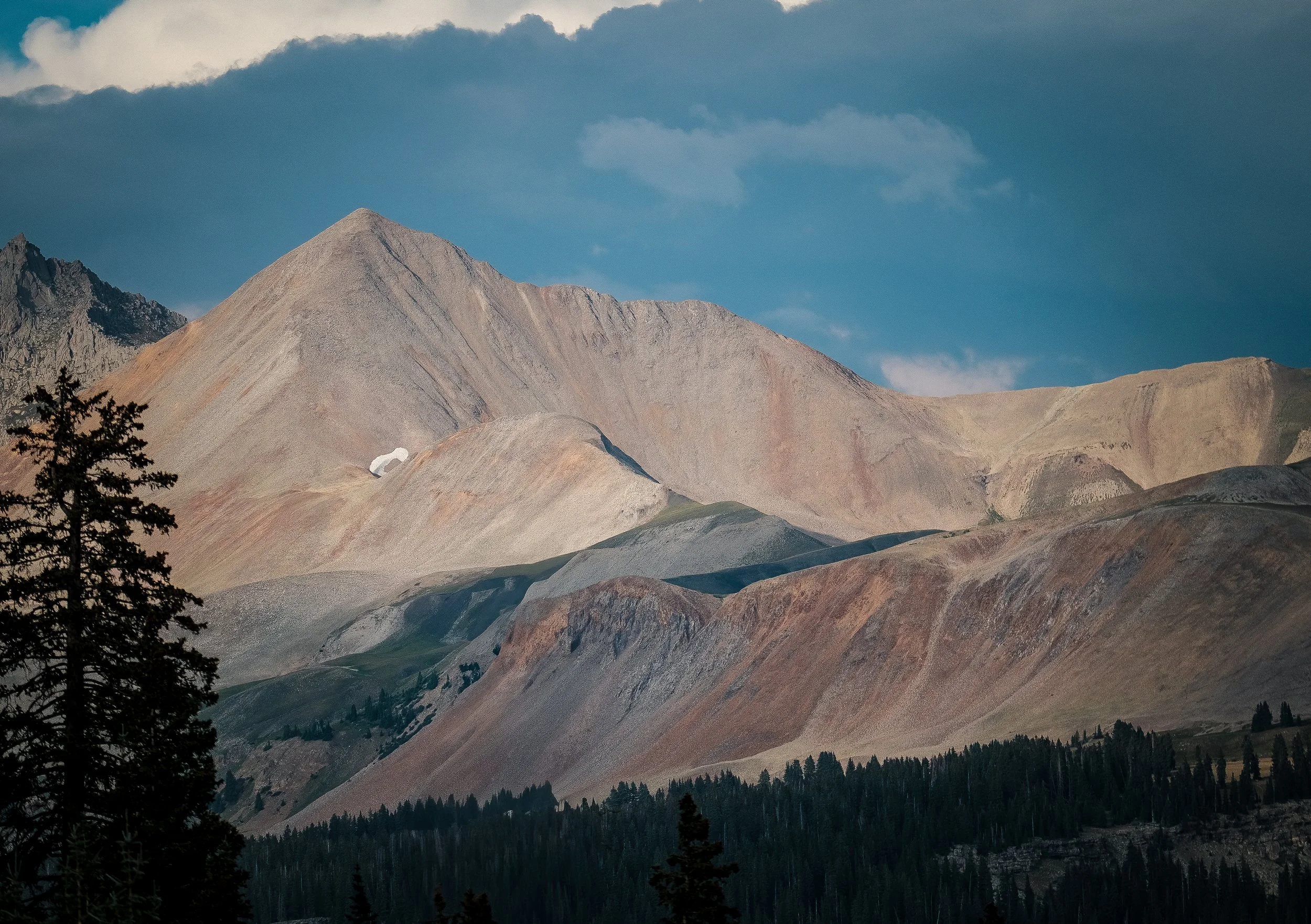
This 100 mile ultra marathon starts and finishes just north of Durango, Colorado. The race will take you through some of the most stunning and rugged terrain with breathtaking views of the Colorado Trail, Engineer Mountain, Wilson group of 14ers, Lizard Head, and many other incredible peaks and valleys in this region.
With an average run elevation of 10,000′ feet, and 19,000’ feet of vertical climbing, you’ll be challenged by steep ascents and descents, and possibly, variable weather conditions along your 100 mile trek.
38 hour cut-off
Start: 6am MT Friday
Finish: 8pm MT Saturday

Race Details
Packet Pick-Up:
Thursday, 2:00 PM – 6:00 PM MT @ Durango Running Company*
*let rd@sanjuansoftie.com know if you can’t make this check-in
Course
~19,000 ft total elevation gain*
average elevation of 10,282 ft
highest point: 12,438ft on Colorado Trail
*we are using CalTopo for elevation calculations
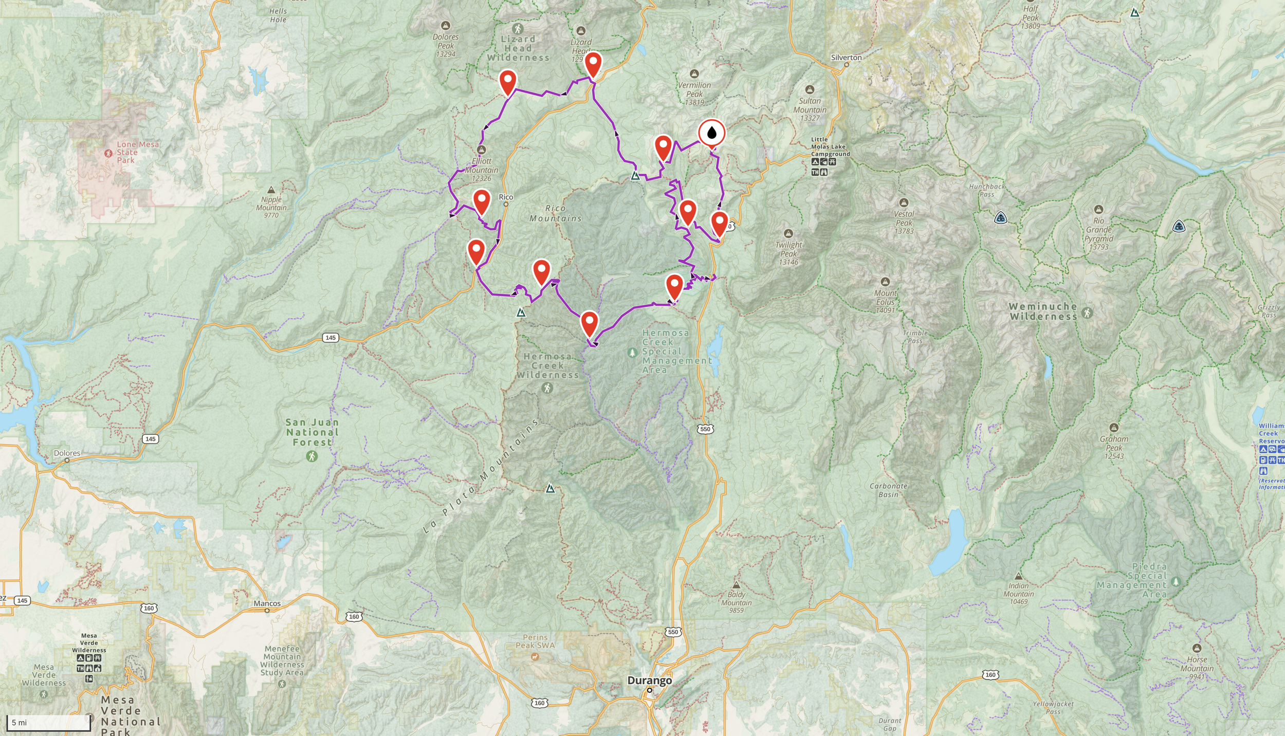

| Aid Station | Total Miles | Elevation (ft) | Distance to Next (mi) | Gain/Loss to Next (ft) | Cumulative Gain/Loss (ft) | Cutoff | Type | Crew Access | Drop Bags |
|---|---|---|---|---|---|---|---|---|---|
| Start | 0 | 8,770 | 8.3 | +1,902-268 | +0-0 | 6:00 AM | Full | Yes | No |
| Cascade #1 | 8.3 | 10,404 | 11.2 | +845-2,174 | +1,902-268 | — | Basic | No | No |
| EMT #2 | 19.5 | 9,075 | 8.5 | +3,012-614 | +2,747-2,442 | 12:30 PM | Full | No | Yes |
| Engine Creek #3 | 28 | 11,473 | 7.8 | +1,611-1,854 | +5,759-3,056 | — | Basic | No | No |
| Middle of Nowhere #4 | 35.8 | 11,230 | 10 | +950-2,150 | +7,370-4,910 | 8:00 PM | Full | No | Yes |
| Cross Mountain #5 | 45.8 | 10,030 | 7 | +1,167-931 | +8,320-7,060 | 10:00 PM | Full | Yes + Pacers | Yes |
| Calico #6 | 52.8 | 10,266 | 12 | +3,278-3,298 | +9,487-7,991 | 12:00 AM | Full | No | No |
| Burnett #7 | 64.8 | 10,246 | 6.5 | +159-1,954 | +12,765-11,289 | — | Basic | No | No |
| Ryman Creek #8 | 71.3 | 8,451 | 8.6 | +2,663-310 | +12,924-13,243 | 8:00 AM | Full | Yes + Pacers | Yes |
| Corral #9 | 79.9 | 10,804 | 7.9 | +212-2,614 | +15,587-13,553 | 11:30 AM | Full | No | No |
| Big Lick #10 | 87.8 | 8,402 | 7.7 | +2,429-529 | +15,799-16,167 | — | Basic | No | No |
| Elbert Creek #11 | 95.5 | 10,302 | 7.9 | +330-1,862 | +18,228-16,696 | 6:00 PM | Full | Yes + Pacers | Yes |
| Finish | 103.4 | 8,770 | — | — | +18,558-18,558 | 8:00 PM | Full | Yes | No |
Personal Accountability
We are STOKED to get to share this awesome area we get to call home with you. We love ultrarunning because of the experiences it allows us to have in beautiful places, the connections we forge through it, and - time and time again - the things we learn about ourselves and our lives through committing to, preparing for, and executing through really hard things.
But we also want to leave no doubts - this is a RUGGED MOUNTAIN RACE. We have done our very best to manage the large-scale factors and mitigate risk in order to give you this opportunity to run 100 miles through the mountains in a more accessible way. By choosing to take on this adventure, you are also choosing to take on some responsibility.
Navigation
We do our best to mark the course clearly, but things happen; severe weather moves in. Markings may get blown, torn, blocked, or eaten. We provide links to maps and GPX files to make sure that we give you ample opportunities to ensure that you can find your way along the course no matter what. We highly recommend studying the route ahead of time, making sure you have maps, a downloaded GPX that will be functional without cell service, and your own route notes if needed. While racing, make sure you are staying alert, and making sound choices when conditions change. You can expect to see pink flags - in the form of ribbons as well as staked flags, that all include reflective tape - as well as directional or “wrong way” signs at intersections. But again - make sure you have a backup plan.
Ask if you need help
There is no honor in trying to stubbornly grit something out that you may be unprepared for. If you know that you are getting in over your head and don’t do anything about it, you are putting yourself and others at risk.
Every runner is required to have a satellite tracker, which will have messaging capacity to some degree; learn how it works ahead of time, have it set up to message us or your crew, and be ready to use it if needed. Perhaps you get some cell service up high and can check in with your crew to let them know that you’re running behind schedule, but okay. An email shortly before the race will include the number for race headquarters, so that you can give it to crew members and save it for yourself. There will also be sweepers following the last runner along every section of the course, who will have a satellite phone and be able to assist you if you need.
Cutoffs and dropping
We hope you have the best race possible, but please also know when to pull the plug. Get familiar with the Aid Station Chart. If you come in shortly before a cutoff and know that you are slowing down while going into the next remote section, only to end up hours behind or decide that you don’t want to continue at the next aid - you are adding a lot of complexity to everyone’s days and making exhausted hardworking volunteers wait for and worry about you. ESPECIALLY when that aid station is remote or does not have crew access. IF YOU CHOOSE TO DROP, IT IS YOUR RESPONSIBILITY TO GET YOURSELF OUT. Aid Station volunteers cannot be expected to have the capacity to get you out. Much of our course is very remote, and some aid stations are only accessible via hiking, OHVs, or rough 4wd roads. Have backup plans, know which Aids will give you best case scenarios, and make smart choices if you need to.


FAQs
-
The SJS starts and ends a few miles north of Durango, CO. Durango is a full service town on the border of the San Juan mountains. Access is possible via road (approximately 3 hours from Albuquerque and 6 hours from Denver) or air through La Plata County Airport.
-
The SJS is approximately 104 miles long. No other distances are currently offered
-
We strongly encourage having completed other mountain ultras before attempting SJS. That said, we will not be gatekeeping this race; if you feel prepared, you are welcome to run.
-
Yes. For your safety, all runners are required to carry a rain jacket, 2 light sources, gloves, whistle, hat, water capacity, and cup/bowl throughout the race. Starting in 2026, we also require satellite tracking devices. The race director reserves the right to require rain pants depending on weather forecast; a decision to require rain pants will be communicated to runners at least 5 days before the event. A tracker may be required; this will also be communicated with plenty of advanced notice. Required gear may be checked at any time by race staff/ volunteers, including at the starting line, aid stations, on the course, or at the finish. Failure to carry all required gear may result in a DQ. In the event of a dispute, the race director has final say.
-
Yes! First, second, and third place prizes for men and women will be provided by Durango Running Company, as well as a cash prize provided by the race: $500 for first, $250 for second, and $100 for third.
-
Yes. This can include a runner’s primary headlamp and an emergency keychain/fob light. Light belts, flashlights, etc. are welcome as well. No, a phone doesn’t count.
-
Yes. Starting in 2026, we require satellite tracking. You can register your own device on our live tracking or rent one for a fee from our tracking provider MAProgress. The details on how to do it all will be sent out a month or so before the race. Please reach out to us at rd@sanjuansoftie.com if you have any concerns or questions or if the extra cost is an issue for you.
-
Yes. Poles would be quite helpful.
-
Yes, pacers are allowed starting at mile 45.5 at the Cross Mountain aid station. Pacers can join runners at Cross Mountain, Ryman Creek, and Elbert Creek aid stations. (These locations are indicated in the aid station chart above). Runners are allowed 1 pacer at a time. All pacers must complete a waiver and have a pacer bib before joining their runner.
-
No muling allowed.
-
Yes, all participants must be at least 18 years old on the day of the race.
-
Deferrals for pregnancy will be considered. All other reasons, including injury, travel restrictions, or failure to train do not qualify for deferral. If you will not be able to run, please unenroll yourself on Ultrasignup or let the race director know so that we can make space for another runner.
-
As of 2026, we maintain a waitlist and no longer allow bib transfers. Your spot will go to the next person on the list!
-
Compared to other 100 mile races in the area (Hardrock, Ouray 100, High 5), this is easy! But make no mistake – this is a challenging mountain ultra with significant vert and exposure above treeline.
-
Not yet!
-
As many folks who live in the west are likely aware, it has been a sad winter for our snowpack. The San Juans currently have the second-worst snowpack in our recorded history, and there is not much hope of that improving this spring. As we hopefully showed last year, in the case of a fire on or near the course, we will do our very best to work with the Forest Service to reroute or find ways to still make the event happen. Unfortunately, smoke from wildfires throughout the west may also be a large concern this year. We will be monitoring Air Quality Index leading up to and on the morning of the race, and reserve the right to cancel if it is at unsafe levels (150 or above). Our insurance does not cover circumstances like wildfires, and many of our costs for the race are paid long before race day; we will refund as much as we are able in the case of a cancellation, but cannot make any guarantees. We also encourage runners who are traveling to us to seek out refundable travel and/or lodging, just in case!
Volunteers Make the Race Happen
Thank you to our sponsors


Contact SJS
Have questions? Email us and someone will get back to you soon. We aim to respond promptly, but the SJS crew is a labor of love, so please exercise some patience.